
Britain boasts some breathtaking UNESCO World Heritage Sites, from the historic cities of Edinburgh and Bath to the beautiful British Coastal World Heritage Sites, such as the Orkney Islands and the Jurassic Coastline. A World Heritage Site is a cultural or natural landmark that has been recognised by the United Nations Educational, Scientific and Cultural Organisation (UNESCO), where each World Heritage Site is held in collective trust, ‘belonging to all the peoples of the world, irrespective of the territory on which they are located’, and is legally protected by international treaty.
In 2025, the United Kingdom had 34 World Heritage Sites, of which five are in overseas territories. Below you can see the complete list ordered by the date when each landmark was officially recognised:
- Castles and Town Walls of King Edward, Gwynedd, Wales (1986)
- Durham Castle and Cathedral, County Durham, England (1986)
- Ironbridge Gorge, Shropshire, England (1986)
- St Kilda, The Outer Hebrides, Scotland (1986)
- Giant’s Causeway and Causeway Coast, County Antrim, Northern Ireland (1986)
- Stonehenge, Avebury and Associated Sites, Wiltshire, England (1986)
- Studley Royal Park, including the Ruins of Fountains Abbey, North Yorkshire, England (1986)
- Blenheim Palace, Oxfordshire, England (1987)
- City of Bath, England (1987)
- Hadrian’s Wall (Frontiers of the Roman Empire), England (1987)
- Palace of Westminster, Westminster Abbey and St Margaret’s Church, London, England (1987)
- Canterbury (Canterbury Cathedral, St Augustine’s Abbey and St Martin’s Church), Kent, England (1988)
- Henderson Island, South Pacific (1988)
- Tower of London, England (1988)
- Gough and Inaccessible Islands, South Atlantic (1995)
- Old and New Towns of Edinburgh, Scotland (1995)
- Maritime Greenwich, London, England (1997)
- Heart of Neolithic Orkney, Orkney Islands, Scotland (1999)
- Blaenavon Industrial Landscape, Gwent, Wales (2000)
- Historic Town of St George and Related Fortifications, Bermuda (2000)
- Derwent Valley Mills, Derbyshire, England (2001)
- Jurassic Coast – Dorset and East Devon, England (2001)
- New Lanark, South Lanarkshire, Scotland (2001)
- Saltaire, West Yorkshire, England (2001)
- Royal Botanic Gardens, Kew, London, England (2003)
- Cornwall and West Devon Mining Landscape (2006)
- Pontcysyllte Aqueduct and Canal, Wrexham, Wales (2009)
- The Forth Bridge, Edinburgh, Scotland (2015)
- Gorham’s Cave Complex, Gibraltar (2016)
- The English Lake District, Cumbria, England (2017)
- Jodrell Bank Observatory (2019)
- Great Spa Towns of Europe (2021) – The UK has City of Bath
- The Slate Landscape of Northwest Wales (2021)
- The Flow Country (2024)
The following was delisted in 2021 but is still well worth a visit:
- Maritime Mercantile City, Liverpool, England (2004)
Not all of these heritage sites are relevant to a coastal website, and so in the next section, we focus on the eight that have a UK coastal location:
- Castles and Town Walls of King Edward, Gwynedd, Wales
- St Kilda, The Outer Hebrides, Scotland
- Hadrian’s Wall (Frontiers of the Roman Empire), England
- Heart of Neolithic Orkney, Orkney Islands, Scotland
- Jurassic Coast – Dorset and East Devon, England
- Giant’s Causeway and Causeway Coast, County Antrim, Northern Ireland
- Cornwall and West Devon Mining Landscape
- The English Lake District, Cumbria, England
1. Castles and Town Walls of King Edward, Gwynedd, Wales


The Castles and Town Walls of King Edward are actually four separate sites in Gwynedd, Wales, that were built in the late 13th century and early 14th century. UNESCO considers these four to be among the finest examples of late 13th- and early 14th-century military architecture in Europe.
The castles were either new fortifications or existing ones reinforced by the English King Edward I when, in 1283, he expanded his control into north-west Wales. He embarked on an ambitious and costly project to construct an “Iron Ring” of castles and new towns to accommodate English settlers. All were built by the same man, James de Saint George from the Savoy, the king’s chief architect in Wales.
These monuments are some of the best examples of military and town defences in the United Kingdom’s history:
- Caernarfon (1283) castle and town walls provided a defensive circuit around Caernarfon.
- Castle and town walls of Conwy (1283-1289), a rectangular castle built on a coastal ridge, originally overlooking an important River Conwy crossing point.
- Castle of Beaumaris (begun in 1295, but never completed) is a concentric castle with a moat, the last and largest of the castles to be built by King Edward.
- Harlech Castle (1283) is another concentric castle constructed atop a cliff close to the Irish Sea.
2. St Kilda, Outer Hebrides, Scotland

St Kilda is a dramatic landscape of exceptional cliffs and underwater scenery on a remote and uninhabited archipelago within Scotland’s Outer Hebrides, located in the North Atlantic off the west coast of the Scottish mainland. The archipelago, renowned for its seabird breeding, consists of the islands in size order of Hirta, Soay (‘sheep island’), Boreray (‘the fortified isle’) and the island of Dùn (‘fort’). Dùn protects Village Bay from the prevailing southwesterly winds and was at one time joined to Hirta by a natural arch. Smaller islets and stacks in the group include Stac an Armin (‘warrior’s stack’), Stac Lee (‘grey stack’) and Stac Levenish (‘stream’ or ‘torrent’).
Hirta, the largest island, was the only one to be occupied, with the last remaining people requesting evacuation in August 1930 due to a lack of resources to sustain themselves. The remains of four settlements are left, with structures spanning all ages, including a medieval village.
Today, over 1 million seabirds use the islands, and St Kilda is a breeding ground for many important seabird species, including Atlantic Puffins, Northern Gannets, Leach’s Petrels, and Northern Fulmar.
The heritage site is not just the islands, but in 2004 was also extended to include the surrounding sea, which is home to minke and killer whales, harbour porpoises, Risso’s dolphins, Atlantic white-sided dolphins, white-beaked dolphins, and Atlantic Grey seals.
Access to the islands is only by boat to the jetty in Village Bay, Hirta. Many tour options depart from Skye and destinations such as Oban and Mallaig. If you intend to use your own boat, please get in touch with the Ranger upon arrival.
The only accommodation on the island is a small campsite, with room for a maximum of 6 people and due to the limited space, booking is essential.
3. Hadrian’s Wall (Frontiers of the Roman Empire)

The “Frontiers of the Roman Empire” encompasses two sections of the Upper German-Raetian Limes in Germany, as well as Hadrian’s Wall and the Antonine Wall, located further north in England and Scotland, respectively. This is part of a frontier known as the ‘Roman Limes’, which originally stretched more than 5,000km (3,107 miles) from the Atlantic coast of northern Britain through Europe to the Black Sea.
Hadrian’s Wall was built under the orders of the Roman Emperor Hadrian in AD 122 “to separate Romans from Barbarians”. It took six years to build the wall 117km (73 miles) long where it formed the most northern border of his empire. Later, there was some Roman expansion further north, resulting in the construction of the smaller Antonine Wall, which spanned approximately 63 kilometres (39 miles).
Today, the ruins of these Limes consist of forts, watchtowers, ditches and walls. There are also some civilian settlements in some parts of the Roman Limes. The National Trust owns a six-mile stretch that includes Housesteads Fort, the best-preserved of 13 outposts along the wall.
4. Heart of Neolithic Orkney, Orkney Islands, Scotland

The Heart of Neolithic Orkney refers to a group of Neolithic monuments found on Mainland, the largest island of the Scottish Orkney Islands. The structures were built between 3000 BC and 2000 BC, with archaeological evidence suggesting that they were important social and religious centres.
The designated area consists of four sites, which are spread out over two Mainland locations just over 6km apart:
- The Neolithic village of Skara Brae is a settlement composed of stone-built houses with stone furnishings.
- Maeshowe a burial mound built on an artificial platform, with an interior passage and chambers. It is aligned so that the rear wall of its central chamber is illuminated on the setting sun of the winter solstice. Maeshowe was looted by Vikings in about the 12th century and more than thirty runic inscriptions were left behind on the walls of the chamber.
- Standing Stones of Stenness: 12 large standing thin stone slabs, 4 of them were part of a stone circle; it also includes the 5.5m Watch Stone.
- Ring of Brodgar: a series of tall stones (originally 60, now only 27 left) forming a 104m diameter circle.
5. The Jurassic Coast – Dorset and East Devon Coast, England
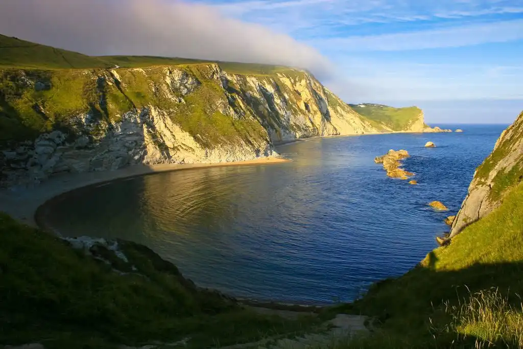
The Jurassic Coast is England’s only natural World Heritage site, stretching from Exmouth in East Devon to Studland in Dorset. The rock formations and fossils of the Jurassic Coast chart 185 million years of the Earth’s history, with its fossils and geological features drawing visitors and scientists for over 300 years.
The National Trust protects one-third of this stunning 154km (95 miles) coastline, which remains accessible and beautiful. Many visitors enjoy the coastal walks and cliff-top views of this natural World Heritage Site, where the South West Coast path provides easy access over its entire length.
Rock formations from the Triassic, Jurassic, and Cretaceous eras are exposed, with large numbers of animal (marine and terrestrial) and plant fossils being discovered here, as well as fossil dinosaur footprints.
With every storm and high tide, the coast is impacted, revealing fossils, making this an exceptional area for beachcombing. Lyme Regis Museum as well as having displays also organises regular fossil walks, talks and fossil-hunting expeditions.
6. Giant’s Causeway and Causeway Coast, County Antrim, Northern Ireland
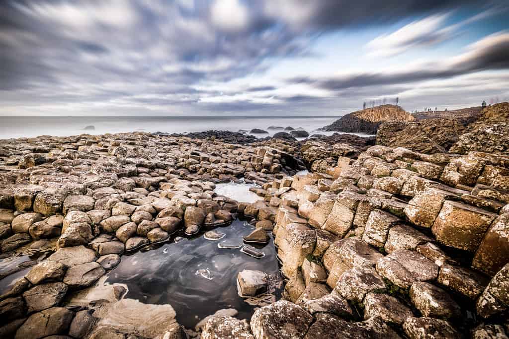
The Giant’s Causeway is a natural rock formation formed by the cooling of lava millions of years ago. The causeway is located about 3 km (1.8 miles) north of the town of Bushmills along the North Atlantic coast of County Antrim, Northern Ireland.
This is Northern Ireland’s only World Heritage site and a spectacular natural phenomenon with over 40,000 interlocking columns of basalt. The tops of the columns form stepping stones that lead from the cliff’s foot and disappear into the sea, which is also the inspiration for legends of giants striding over the sea to Scotland. Most of the columns are hexagonal; however, there are some with four, five, seven and eight sides. The tallest are approximately 12 metres (39 ft) high, and the solidified lava in the cliffs is 28 metres (91 ft) thick in some places.
This UNESCO World Heritage Site is one of Northern Ireland’s most popular tourist destinations, with much of it owned and managed by the National Trust, which offers a Visitor Centre and cafe.
7. Cornwall and West Devon Mining Landscape, England

The Cornwall and West Devon landscape was transformed in the 18th and 19th centuries by the mining of copper and tin, with steam technology being pioneered within the many mines.
The coastal landscape is dotted with ruined mines, engine houses, waste and spoil heaps, railways and canals. The region made a significant contribution to the Industrial Revolution, with many of the technologies used for mining being exported to other parts of the world. Surviving Cornish engine houses can be found in Spain, South Africa, Mexico, and Australia.
During the 18th to 19th centuries, copper and tin mining were booming in Cornwall and West Devon. The area consisted of deep underground mines, foundries, ports, harbours, engine houses, and ancillary industries. The region produced approximately two-thirds of the world’s copper supply.
The World Heritage site is split over 10 locations:
- St Just Mining District
- The Port of Hayle
- Tregonning and Gwinear Mining Districts with Trewavas
- Wendron Mining District
- Camborne and Redruth Mining District with Wheal Peevor and Portreath Harbour
- Gwennap Mining District with Devoran and Perran and Kennall Vale
- St Agnes Mining District
- The Luxulyan Valley and Charlestown
- Caradon Mining District
- Tamar Valley Mining District with Tavistock
In recent times this mining history has been brought to many’s attention by the television series Poldark, we have an article giving details of some of the filming locations.
8. The English Lake District, Cumbria, England

We have included the Lake District, although it truly holds World Heritage status due to its beautiful lakes and mountains; we also must not forget that it consists of a small stretch of the Cumbria coastline, from Seascale to Millom.
There are four central valleys leading from the coast into the Lake District park: Ennerdale, Eskdale, Wasdale and Dunnerdale. Wasdale is the home of England’s highest mountain, Scafell Pike, and the deepest lake, Wastwater, whilst the Eskdale Railway takes you to the coast and the Parks’ only coastal town, Ravenglass, with its scenic estuary.
Feature photo by Chris Parker2012 ![]()